本文
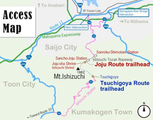
Access
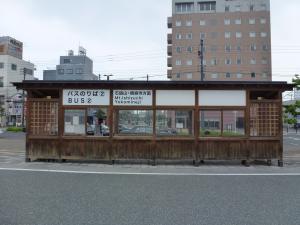
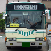
Bus
Saijo to the Joju trailhead
Take the Setouchi bus bound for Nishinokawa
↓ (54 min.)
Get off at the Ropeway-mae stop
↓ (approx. 5 min.)
Take the Ishizuchi Tozan Ropeway from Sanroku-Shimotani Sta. to Sancho Sta.
↓ (20 min. with wait, time may vary depending on ropeway schedule)
From the upper station, it is 7 min. to the ski area and 20 min. to Joju-sha Shrine.
*Time from JR Iyo-Saijo Station to the Joju trailhead: approx. 1 hr. 40 min.
【Timetable】 Setouchi Bus for Nishinokawa (via Ishizuchi Ropeway)
| JR Iyo-Saijo Station | Ishizuchi Tozan Ropeway |
|---|---|
| 7:47 | 8:41 |
| 10:27 | 11:21 |
| 13:37 | 14:31 |
| 16:23 | 17:17 |
| Ishizuchi Tozan Ropeway | JR Iyo-Saijo Station |
|---|---|
| 6:56 ※ | 7:50 ※ |
| 9:12 | 10:06 |
| 12:02 | 12:56 |
| 15:17 | 16:11 |
| 17:23 | 18:17 |
※Does not operate on Sundays/holidays
Car
Saijo to the Joju trailhead
【From Matsuyama】
From the Matsuyama Expressway, exit Iyo-Komatsu I/C and turn right onto Route 11.
↓ (approx. 4 km, 10 min.)
Turn right (southward) at the Himi Intersection.
↓ (approx. 5 km, 15 min.)
Turn right at the Kurose Lake T-intersection.
↓ (approx. 7 km, 15 min.)
Turn left at the three-road junction at Komatsu-Kawaguchi.
↓ (approx. 3 km, 10 min.)
Park at the Ishizuchi Tozan Ropeway station and take the ropeway to the upper station.
↓ (20 min. with wait, time may vary depending on ropeway schedule)
From the upper station, it is 7 min. to the ski area and 20 min. to Joju-sha Shrine.
*Time from Iyo-Komatsu I/C to the Joju trailhead: approx. 1.5 hours.
【From Takamatsu】
From the Matsuyama Expressway, exit Iyo-Saijo I/C and turn left onto Route 11 heading west toward Komatsu.
↓ (approx. 7 km, 15 min.)
Turn left at the intersection just after the Kamogawa River bridge (before Family Mart). Travel southward on Route 194.
↓ (approx. 5 km, 10 min.)
Slight right at the junction between Route 194 and Route 12 (onto Route 12).
↓ (approx. 7 km, 15 min.)
Turn left at the three-road junction at Komatsu-Kawaguchi.
↓ (approx. 3 km, 10 min.)
Park at the Ishizuchi Tozan Ropeway station and take the ropeway to the upper station.
↓ (20 min. with wait, time may vary depending on ropeway schedule)
From the upper station, it is 7 min. to the ski area and 20 min. to Joju-sha Shrine.
Time from Iyo-Saijo I/C to the Joju trailhead: approx. 1 hr. 45 min.
【From the Nishiseto Expressway (Shimanami Kaido)】
From the Shimanami Kaido Expressway, exit Imabari I/C and turn left onto Route 196 heading south toward Komatsu.
↓ (approx. 22 km, 45 min.)
At the terminus of Route 196, turn left onto Route 11.
↓ (approx. 2 km, 5 min.)
Turn right (southward) at the Himi Intersection.
↓ (approx. 5 km, 15 min.)
Turn right at the Kurose Lake T-intersection.
↓ (approx. 7 km, 15 min.)
Turn left at the three-road junction at Komatsu-Kawaguchi.
↓ (approx. 3 km, 10 min.)
Park at the Ishizuchi Tozan Ropeway station and take the ropeway to the upper station.
↓ (20 min. with wait, time may vary depending on ropeway schedule)
From the upper station, it is 7 min. to the ski area and 20 min. to Joju-sha Shrine.
*Time from Imabari I/C to the Joju trailhead: approx. 2 hr. 10 min.
Matsuyama to Tsuchigoya trailhead
【From Matsuyama】
From the Matsuyama Expressway, exit Matsuyama I/C and turn right onto Route 33 (for Kochi)
↓(approx. 26 km, 30 min.)
Turn left onto Route 12 at the Kuma Junior High School intersection
↓(approx. 14 km, 20 min.)
Turn left onto Route 494 at the Takiwatasebashi intersection (a T-junction)
↓(approx. 9 km, 10 min.)
Keep right onto Prefectural Route 12 at the Tsusenbashi intersection
↓(approx.11 km, 15 min.)
Turn right at the gate for Ishizuchi Skyline (go straight for Omogo Mountain Museum and Omogo Gorge)
↓(approx. 17 km, 30 min.)
Arrive at Tsuchigoya
*Time from Matsuyama I/C to the Tsuchigoya trailhead: approx. 1 hr. 45 min.